


As a new committee of experts is set to take up what appears to be an increasingly vexatious task of defining an ancient hill range, I feel compelled to put on record why, as then director general (DG), Forest Survey of India (FSI), I opposed the definition based on 100 m elevation for the Aravalli.
It is also as good a time as any to remember why it may not be necessary to reinvent the wheel, because the Aravalli hills were meticulously mapped back in 2011 by the FSI under a very able director general, the late R D Jakati.
Pursuant to the Supreme Court (SC) order dated February 19, 2010, the central empowered committee of the SC assigned the task of mapping mining areas in the Aravalli hills of Rajasthan to the FSI.
Subsequently, after failing to obtain any map of Aravalli Hills and Ranges from other mapping agencies, the FSI embarked upon the arduous task of mapping by itself and submitted the delineated map of the Aravalli hills for 15 districts of Rajasthan on April 13, 2011.
The issue was revisited when a committee of secretaries and representatives of technical institutions was constituted, as per directions of the SC on May 9, 2024, to find an uniform definition of Aravalli Hills and Ranges.
The committee submitted its report in its affidavit on October 3, 2025. As DG, FSI, I was a member of the committee and had opposed the definition based on 100 m elevation above a reference level due to its serious environmental impacts. After the SC judgment on November 20, 2025, multiple reports by this newspaper led to protests by environmentalists. On December 29, the SC stayed the November judgment with directions to form a new committee to examine the issue.
While this committee is in the process of being set up, I think it is important to highlight a few points:
The recent analysis on the Aravalli hills and their definition, extent, distribution, demarcation and altitudinal zonation was done during my tenure as DG, FSI. I studied the application of remote sensing and GIS from ITC, The Netherlands, and spent six months at ESRI, USA. I may claim a modest understanding of the technology.
While serving as DG, I had analysed the data for 15 districts of Rajasthan to ascertain the impact of excluding hills below 100 m from the Aravalli. Only 15 (erstwhile of 2011) districts were used because the Rajasthan government had earlier stated that the Aravalli is spread over only these 15 districts.
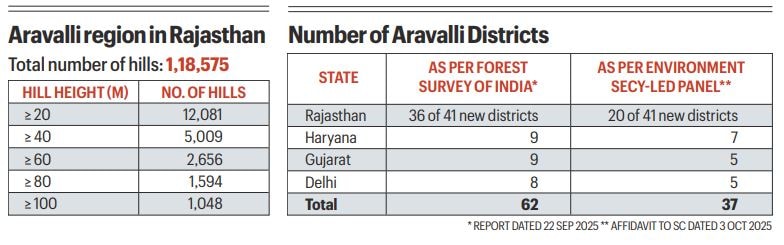
Digitised contours of these 15 districts were available with the FSI. The contour dataset was digitised painstakingly from 1:50,000 Survey of India topographic sheets in 2011. Based on this dataset, the FSI had proposed to the SC the boundary of Aravalli hills using 3-degree slope criteria in 2011. The results of the analyses carried out by the FSI in 2025 were reported by this newspaper last November (see table 1).
In order to answer the SC’s query on the accuracy of this study, it needs to be repeated by the proposed committee, without changing the Survey of India sheets-based dataset created during the tenure of former DG FSI Jakati.
According to the FSI’s report dated September 22, 2025, as many as 62 districts qualify to be included in the Aravalli. In comparison, the environment secretary’s committee listed only 37 districts in their affidavit on October 3, 2025. Even prominent districts such as Sawai Madhopur and Chittaurgarh, famous for their forts, were excluded from the list of Aravalli districts by the secretary’s committee, even though they were included in the Aravalli Green Wall Project and also in the Ministry of Culture’s UNESCO World Heritage sites as “Hill Forts of Rajasthan”.
The districts to be included along with reasons for inclusion have been mentioned in detail in the FSI’s report. As the table shows, the omission is stark (see table 2) and, if not rectified, the hills are destined to be obliterated in many districts without even being heard.
The new committee should also refer to FSI’s September 2025 report to take note of the reasons why various government agencies — such as the environment ministry, the Ministry of Culture, Central Ground Water Board, Geological Survey of India etc — have been including these districts under the Aravalli.
The new committee may also like to reexamine the robustness of the 3-degree slope criteria adopted by the FSI earlier as it is time-tested and identifies the hills in the Aravalli region quite accurately.
Rajasthan has only 8 per cent geographical area under forest and tree cover (ISFR, 2023) and the majority of this lies in the Aravalli region. The utmost care needs to be taken not to disturb this delicate balance.
Singh is former director general, Forest Survey of India
