



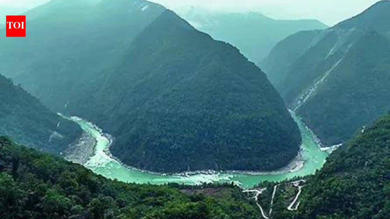
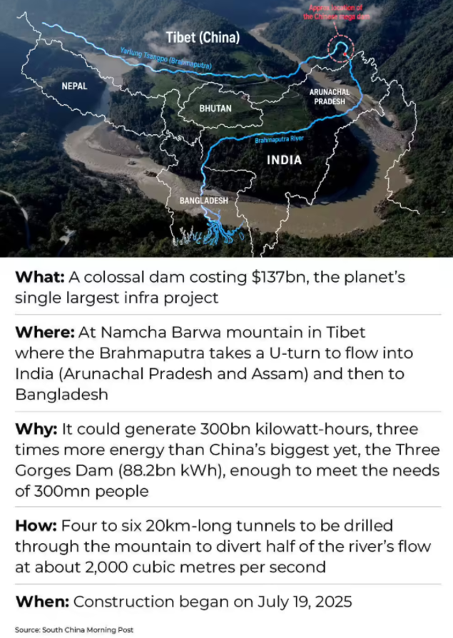
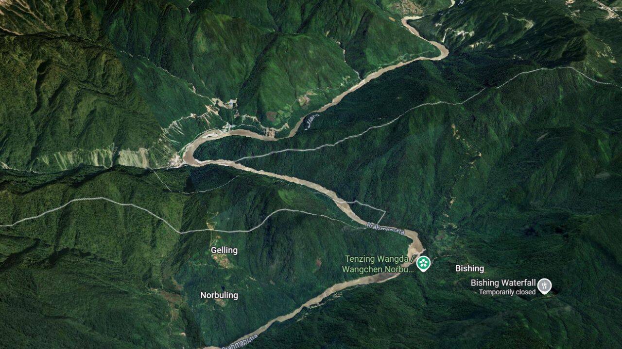
NEW DELHI: China’s construction of the world’s largest hydropower project on the Yarlung Tsangpo, known downstream as the Brahmaputra, has renewed concerns in India over water security, seismic safety, ecological impacts and the strategic implications of Beijing’s growing control over infrastructure on a transboundary river.The project, commonly known as the Medog Dam or the Yarlung Tsangpo Hydropower Project, is being built at the river’s dramatic “Great Bend” in Medog County in Tibet, where the river makes a sharp U-turn before entering Arunachal Pradesh as the Siang River. The site lies close to India’s eastern border, with Gelling, Norbuling and Bishing among the nearest Indian locations.According to the South China Morning Post (SCMP), Chinese Premier Li Qiang described the hydropower project as the “project of the century” while inaugurating construction.
Where is the dam being built?
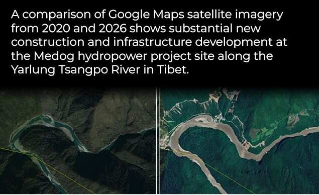
The dam is coming up on the lower reaches of the Yarlung Tsangpo in Tibet’s Medog County, one of the world’s deepest river gorges. Over a stretch of nearly 50 kilometres, the river drops around 2,000 metres, creating one of the world’s richest hydropower resources.
Scientists have warned that the project could affect one of the world’s richest mountain ecosystems.
According to SCMP, the project will comprise five cascade hydropower stations capable of generating around 300 billion kilowatt-hours (kWh) of electricity annually, more than three times the annual output of China’s Three Gorges Dam.The project is estimated to cost around 1.2 trillion yuan (about $167 billion), making it the costliest hydropower project ever undertaken, according to the newspaper.
Why is the Brahmaputra strategically important?
The Brahmaputra is one of Asia’s most important transboundary rivers. Known as the Yarlung Tsangpo in Tibet, the Siang (or Dihang) in Arunachal Pradesh and the Jamuna in Bangladesh, it flows through China, India and Bangladesh before emptying into the Bay of Bengal.Stretching roughly 2,900 kilometres, the river drains a basin of around 580,000 square kilometres shared by China, India, Bhutan and Bangladesh. China accounts for the largest share of the basin.
The Brahmaputra is the ninth-largest river in the world by discharge and among the world’s largest braided rivers. It is a lifeline for irrigation, agriculture, transportation, fisheries and hydropower across northeastern India and Bangladesh.
Can China stop the Brahmaputra from flowing into India?
Hydrologists say China cannot permanently stop the Brahmaputra from flowing into India because the river receives substantial additional water from heavy monsoon rainfall and numerous tributaries after entering Arunachal Pradesh and Assam.However, experts say a massive upstream reservoir would enable China to regulate the timing and volume of water releases to a certain extent.According to a Reuters report on India’s hydropower strategy, New Delhi fears an upstream Chinese dam on the Yarlung Tsangpo could reduce dry-season flows by as much as 85% under certain operating scenarios, although there is no publicly available evidence suggesting China intends to do so.
Indian officials and strategic analysts fear Beijing could gain greater leverage by controlling key infrastructure upstream.
Experts also distinguish between water diversion and flow regulation. China’s project has been described as a hydropower dam rather than a diversion scheme. Run-of-the-river hydropower projects generally release water downstream after generating electricity, although reservoirs can alter seasonal flows and the timing of releases.India’s concerns extend beyond water availability.According to SCMP, New Delhi increasingly views the project through the prism of national security because the river flows through Arunachal Pradesh, which China claims as “South Tibet.”Indian officials and strategic analysts fear Beijing could gain greater leverage by controlling key infrastructure upstream.Arunachal Pradesh Chief Minister Pema Khandu recently described the project as a potential “water bomb”, warning that river flows could “dry up considerably” while the reservoir is being filled and that sudden releases could increase flood risks downstream, according to SCMP.Experts have also pointed to the absence of a comprehensive water-sharing treaty governing the Brahmaputra between India and China.
Geological concerns over the mega dam
Beyond geopolitics, the project’s location has become the focus of growing scientific scrutiny.According to a PTI report citing the South China Morning Post, Chinese geologists have identified an active fault line beneath the hydropower project that could affect its long-term structural stability.The findings were published in the Chinese-language journal Sedimentary Geology and Tethyan Geology under the supervision of the China Geological Survey.The study found that the Paizhen Fault, an active geological fracture in the eastern Himalayas, has remained active since the Pleistocene.According to the researchers, prolonged tectonic activity has weakened surrounding rock formations, making dam foundations, bridges, roads, tunnels and reservoir infrastructure more vulnerable.“The Paizhen area is located within the reservoir area of the Yarlung Tsangpo downstream hydropower station,” the researchers wrote.They warned that earthquakes could trigger landslides and rock collapses that may threaten engineering infrastructure. The study cited the 2017 magnitude 6.9 Milin earthquake as evidence that the region remains seismically active.Chinese authorities have consistently rejected suggestions that the project poses risks to downstream countries.According to PTI, Beijing has repeatedly maintained that the hydropower project has undergone extensive geological surveys and meets the highest engineering standards.An official Chinese statement issued in December 2024 described it as a safe project that prioritises ecological protection.Chinese Foreign Ministry spokesperson Mao Ning said the project had undergone decades of scientific studies and environmental assessments. According to SCMP, she said China would continue maintaining communication with downstream countries while strengthening cooperation on disaster prevention and mitigation.Chinese officials have also maintained that the project will not adversely affect downstream water flows.Scientists have warned that the project could affect one of the world’s richest mountain ecosystems.According to SCMP, Sichuan-based geologist Fan Xiao described the Yarlung Tsangpo Grand Canyon as a rare biodiversity hotspot located in a geologically unstable region.He warned that constructing multiple mega hydropower stations involving high dams, large reservoirs and extensive tunnel systems could increase landslide risks and cause irreversible environmental damage.Fan also questioned official claims that large hydropower projects are entirely “green”, arguing that the long-term geological and ecological costs remain uncertain.Researchers have additionally raised concerns about the displacement of local communities and the possible impact on culturally significant Tibetan sites.
China suspended hydrological data sharing in 2017: MEA
Concerns over China’s management of transboundary rivers are not new.In a written reply in the Rajya Sabha on February 8, 2018, the Ministry of External Affairs (MEA) confirmed that China did not provide hydrological information on either the Brahmaputra (Yarlung Zangbo) or the Sutlej (Langqen Zangbo) during the 2017 flood season despite existing bilateral Memorandums of Understanding (MoUs).Responding to an unstarred question, then Minister of State for External Affairs Gen. (Dr.) V.K. Singh (Retd.) said China had informed India that the interruption was due to “technical reasons.”The MEA said India continued to monitor transboundary rivers for any abnormalities and regularly raised river-related issues through the India-China Expert Level Mechanism (ELM), established in 2006, as well as through diplomatic channels.
China resumed Brahmaputra data sharing in 2018
China resumed sharing hydrological data on the Siang River, the main stem of the Brahmaputra in India, on May 15, 2018, under the bilateral MoU that requires Beijing to provide river flow information during the flood season from May 15 to October 15, according to officials in India’s then Ministry of Water Resources.The resumption followed concerns in India after China suspended data sharing during the 73-day Doklam standoff in 2017. While many analysts viewed the suspension as linked to deteriorating bilateral ties, Beijing maintained that the interruption was caused by the upgrading of hydrological monitoring stations in Tibet.Data sharing resumed after the 11th meeting of the India-China Expert Level Mechanism on Trans-Border Rivers in Hangzhou in March 2018. Following the meeting, Chinese Foreign Ministry spokesperson Lu Kang said China would continue cooperation on hydrological information.The original MoU on sharing hydrological data for the Brahmaputra was signed in 2002 and renewed in 2008 and 2013. India and China also have a separate agreement covering the Sutlej River, originally signed in 2005 and renewed in 2010.
Could earthquakes threaten the project?
The project sits along the collision zone between the Indian and Eurasian tectonic plates, one of the world’s most seismically active regions.According to the Chinese geological study reported by PTI, the Paizhen Fault has remained active into the Holocene period, with geological evidence suggesting movement as recently as 9,500 years ago.The researchers recommended reinforcing vulnerable slopes and constructing retaining structures to minimise landslide risks.The region has also witnessed glacier collapses and landslides in recent years.According to SCMP, Sayanangshu Modak, a researcher at the University of Arizona, cited the massive 2021 glacier collapse near the Great Bend that temporarily blocked the river and sharply raised water levels, saying such cascading events highlight the vulnerability of large hydropower infrastructure in the region.
Could the dam become a geopolitical lever?
Several analysts believe the project could reshape the strategic balance between China and India.According to SCMP, Sayanangshu Modak said the project would not only showcase China’s engineering capabilities but also strengthen its strategic influence in the region.He also noted that India has accelerated dam construction downstream as part of its own strategy to strengthen water utilisation rights.Shanghai-based security analyst Ni Lexiong told SCMP that although China considers the project an internal matter, the dam could effectively provide Beijing with additional geopolitical leverage because of its upstream location.“It would effectively create geopolitical leverage vis-a-vis India diplomatically,” he said.However, Liu Zongyi, a senior fellow at the Shanghai Institutes for International Studies, argued that concerns over China’s ability to manipulate river flows were overstated and maintained that the project would not fundamentally alter bilateral relations.India has responded by accelerating hydropower development in Arunachal Pradesh.According to Reuters, New Delhi has approved investments of more than $4 billion for two major hydroelectric projects along the Brahmaputra.The 1,720 MW Kamala project, estimated at 260.7 billion rupees, will be developed jointly by NHPC and the Arunachal Pradesh government.The 1,200 MW Kalai-II project, costing 141 billion rupees, will be implemented by THDC India Ltd in partnership with the state government.Reuters also reported that India plans to develop more than 76 GW of hydropower capacity in the Brahmaputra basin by 2047 through a transmission investment programme worth $77 billion.These projects are intended to strengthen India’s energy security while reinforcing its strategic presence along the eastern Himalayan frontier.Construction of the Medog mega dam is expected to take at least a decade because of the engineering challenges posed by the Himalayan terrain. According to SCMP, the project is expected to begin operations in the 2030s.As construction advances, the project is likely to remain under close scientific and geopolitical scrutiny.For India, the debate extends beyond electricity generation. The central questions are whether China’s control over major upstream infrastructure could alter river management, affect downstream ecology, complicate disaster response, or become another strategic factor in an already complex India-China relationship.
